Webquest Part 1 - Ocean Floor Features
Underwater Landforms
Beneath the smooth ocean surface extends an underwater landscape as complex as anything you might find on land. While the ocean has an average depth of 2.3 miles, the shape and depth of the seafloor is complex. Some features, like canyons and seamounts, might look familiar, while others, such as hydrothermal vents are unique to the deep.
|
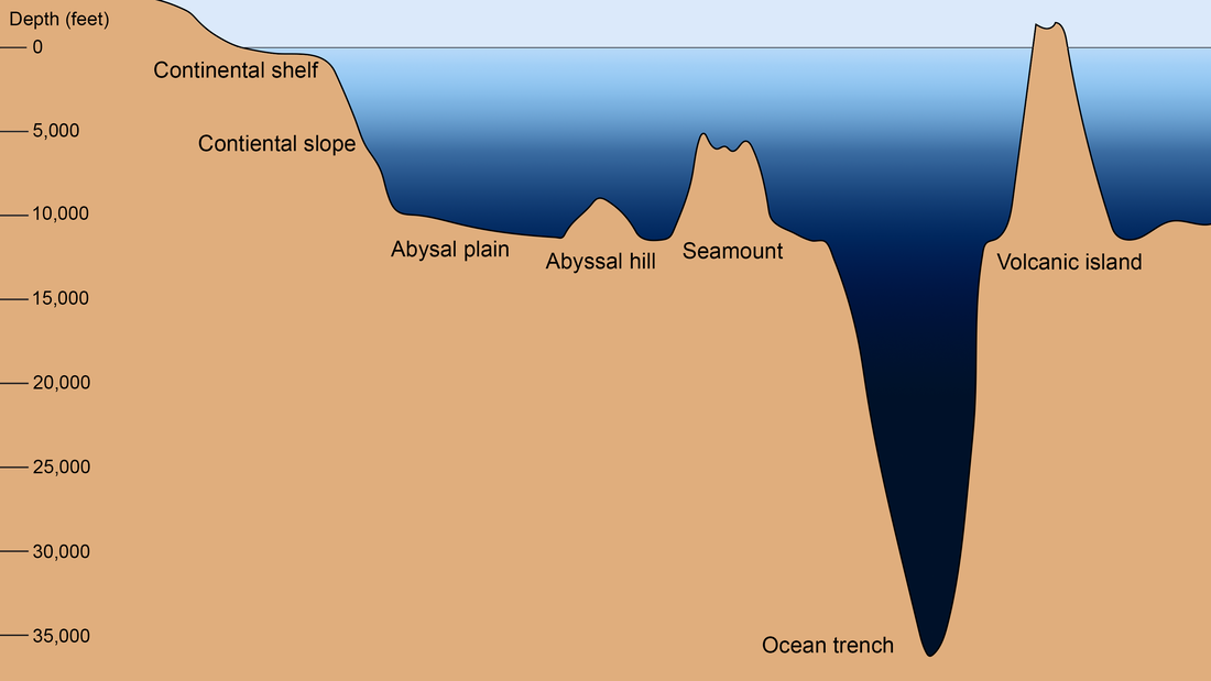
This graphic shows several ocean floor features on a scale from 0-35,000 feet below sea level. The following features are shown at example depths to scale, though each feature has a considerable range at which it may occur: continental shelf (300 feet), continental slope (300-10,000 feet), abyssal plain (>10,000 feet), abyssal hill (3,000 feet up from the abyssal plain), seamount (6,000 feet up from the abyssal plain), ocean trench (36,000 feet), and volcanic island (above sea level). (NOAA Office of Education)
|
Features on the Ocean Floor

|
Continental Shelf:
Starting from land, a trip across an ocean basin along the seafloor would begin with crossing the continental shelf. The continental shelf is an area of shallow water ( usually less than a few hundred feet deep), that surrounds land. It is narrow or nearly nonexistent in some places; in others, it extends for hundreds of miles. The waters along the continental shelf are usually productive, both from light and nutrients from upwelling and runoff. |
The shelf begins at the shoreline and extends out into the ocean. This ocean floor feature is relatively shallow with an average depth of 400 feet and can stretch out from land anywhere from 45 – 900 miles. Most marine organisms live on the shelf or in the waters above it.
|
Continental Slope:
The continental slope begins at edge of continental shelf and continues down to the flattest part of the ocean floor. Imagine walking underwater straight across the continental shelf. Eventually, you would come to the end of the shelf and the ocean floor would start sloping towards the very bottom of the ocean. This descent is called the continental slope. It can be a very steep slope or be more of a gentle, gradual slope. |

|

|
Abyssal Plain:
An abyssal plain is an underwater plain on the deep ocean floor, usually found at depths between 3,000 meters and 6,000 meters. They are among the flattest, smoothest, and least explored regions on Earth. These plains are covered with mud, and the remains of decomposing organisms. Tectonic boundaries (large cracks in the Earth’s crust where tectonic plates meet) run through some areas of the abyssal plain. 
|
Mid-Ocean Ridge:
A mid ocean ridge is an underwater mountain range that forms along tectonic plate boundaries. Magma forces its way through a tectonic boundary, and new ocean floor is formed. This type of plate boundary is responsible for sea floor spreading – a process in which tectonic plates “grow” and push away from each other. This type of plate boundary is known as a divergent boundary.
A mid ocean ridge is an underwater mountain range that forms along tectonic plate boundaries. Magma forces its way through a tectonic boundary, and new ocean floor is formed. This type of plate boundary is responsible for sea floor spreading – a process in which tectonic plates “grow” and push away from each other. This type of plate boundary is known as a divergent boundary.

|

|
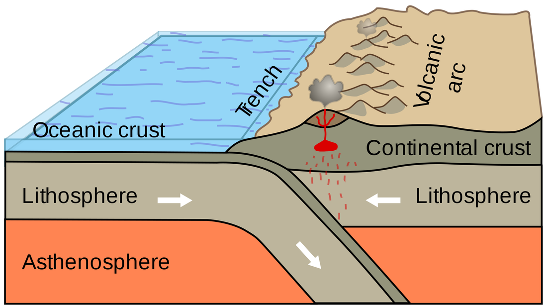
Trench:
An ocean trench is a long, narrow depression in the sea floor. They form along convergent plate boundaries (where two plates move towards each other and one plate is forced under the other). The deepest known point in the Earth’s oceans is a part of the Marianas Trench, and called Challenger Deep. At 25,827 feet, Challenger is deeper than Mt. Everest is tall.
An ocean trench is a long, narrow depression in the sea floor. They form along convergent plate boundaries (where two plates move towards each other and one plate is forced under the other). The deepest known point in the Earth’s oceans is a part of the Marianas Trench, and called Challenger Deep. At 25,827 feet, Challenger is deeper than Mt. Everest is tall.
|

|
Volcanic Islands:
Volcanic islands can form near a plate boundary as a result of tectonic activity. When two tectonic plates collide and one slides under the other, volcanoes on the sea floor can form. Over time those volcanoes build up, some eventually rising above the surface of the ocean. Volcanoes that form near a tectonic plate boundary often form a semi-circular shaped island chain known as a volcanic island arc.
Underwater volcanoes can also form over abnormally hot mantle locations called hot spots. Hot spots can occur at plate boundaries or in the middle of a tectonic plate. As a tectonic plate slowly drifts over a hot spot, a chain of islands is formed.
|
The Hawaiian Islands are volcanic islands formed over a hot spot, pictured in the figure on the right.
|

|

The figure to the left shows how volcanoes form over a hot spot. As the plate moves over the fixed hotspot, a chain of volcanoes forms.
|
Volcanoes that form near a tectonic plate boundary often form a semi-circular shaped island chain known as a volcanic island arc. Example pictured right.
|

|
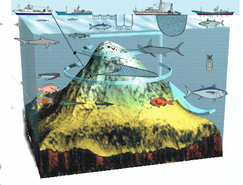
Seamounts:
Along the ocean floor, often near crustal plate boundaries, are underwater mountains called seamounts. Seamounts are actually cone-shaped volcanic mountains with steep sides and a narrow summit, or top. They are mountains of volcanic material that DO NOT break the ocean surface, they rise from the ocean seafloor but are not islands since they do not go above sea level. Some seamounts rise through the ocean’s surface and appear as volcanic islands. Seamounts are most abundant in the Pacific Ocean, possibly because of the activity of plates in the Pacific area. Seamounts are typically formed from extinct volcanoes that rise abruptly and are usually found rising from the seafloor to 3,300–13,100 ft in height.
Along the ocean floor, often near crustal plate boundaries, are underwater mountains called seamounts. Seamounts are actually cone-shaped volcanic mountains with steep sides and a narrow summit, or top. They are mountains of volcanic material that DO NOT break the ocean surface, they rise from the ocean seafloor but are not islands since they do not go above sea level. Some seamounts rise through the ocean’s surface and appear as volcanic islands. Seamounts are most abundant in the Pacific Ocean, possibly because of the activity of plates in the Pacific area. Seamounts are typically formed from extinct volcanoes that rise abruptly and are usually found rising from the seafloor to 3,300–13,100 ft in height.
|

|

Map of seamounts found so far on Earth.
|
Guyots:
Many seamounts do not rise to a peak but have a flat top. Flat-topped seamounts are called guyots (GEE-oze or GEE-oots). Scientists hypothesize that the seamount tops were above sea level at one time and have been removed by wave action. The flattened seamounts later sunk below the ocean surface. Scientists believe the sinking of the guyots was caused by the movement of crustal plates. |

|

